|
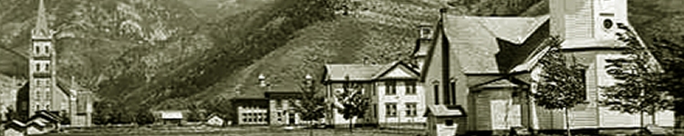
Lincoln County History
On February 20. 191 1, Governor Joseph M. Carey approved an act of the
Wyoming Legislature contaning the following provision: "All that portion of
the State of Wyoming described and bounded as hereinafter in this section set
forth is hereby created and formed a county of the State of Wyoming by the
name of Lincoln County. Said Lincoln County shall be bounded as follows, to wit :
"Commencing at the point where the present boundary line between the counties of Sweetwater and Uinta crosses the township line between townships 18
and 19 north ; running thence west along said township line to its intersection
with the west boundary line of the State of Wyoming; thence north along said
west boundary line of the State of Wyoming to its intersection with the south
boundary line of the Yellowstone National Park; thence east along the south
boundary line of said Yellowstone National Park to the intersection of said
boundary line with the present boundary line between the counties of Bighorn
(Park) and Uinta: thence south along the present east boundary line of Uinta
County to the point where said boundary line intersects the line between town-
ships 18 and 19, the place of beginning.
Lincoln is one of the large counties of the state. Its length from north to
south is about one hundred and eighty miles, and its width is fifty miles, giving
it an area of about nine thousand square miles. The surface is greatly diversified.
In the northern part is Jackson's Hole, or the "Big Game Country." Jackson
Lake, a beautiful body of water, is drained by the Snake River, which flows in a
southwesterly direction into Idaho. The great bend of the Green River passes
through the southeastern part, and in the southwest the county is watered by the
Bear River and its tributaries.
West of the Snake River are the Teton Mountains. which are among the
highest of the Rocky Mountain system. South of the Tetons along the western
boundary of the county lie the Snake River and Salt River ranges, and south of
Jackson's Hole is the Gros Ventre range. There are also a number of isolated
peaks, such as Mount Moran, Virginia Peak, Bald Mountain, Mount Leidy,
Hoback Peak. etc. Between the mountain ranges are beautiful, fertile valleys,
where stock raising is carried on successfully. In 1916 the county stood first
in the number of cattle and fourth -n the number of sheep. More than eight
hundred carloads of sheep and three millions pounds of wool were shipped
from the county during the year.
Trappers, fur traders and passing emigrants were the first white people in
what is now Lincoln County. Fort Bonneville, an account of which is given
in an early chapter of this work, was built in 1832 near the junction of Horse
Creek and the Green River. The site of this old fort was marked by the Oregon
Trail Commission on August 9. 1916. Placer gold was found on the south fork
of the Snake River at an early date and was worked by adventurous prospectors.
One of these. Jack Davis by name, held onto his claim in the Grand Canyon
until his death in 1915. The actual settlement of the county did not begin,
however, until a few years after the close of the Civil War.
In 1868 Beckwith, Quinn & Company took up a tract of 15,000 acres in the Bear
River Valley, about fifty miles north of Evanston, and engaged in stock
raising on a large scale. The first agricultural settler was Justin Pomeroy, who
located a claim on the Fontenelle Creek in September, 1874. In that same year
John Bourne, with his wife and four children, drove over from Cache Valley,
Utah, and settled where the Town of Cokeville now stands. Mr. Bourne made
a living for himself and family by trapping and selling furs. Soon after his
arrival Sylvanus Collett and his family settled in the vicinity. Bourne and
Collett had long been acquainted, having crossed the plains with the early Mormon
emigrants. A Mormon colony settled in the Salt River Valley in 1877.
Star Valley, west of the Salt River range, was settled in the '70s. Emil Stumpf and William White established salt works near the present Town of
Auburn, and hauled their salt over the old Lander Trail, which crossed the valley,
to the mining camps in Idaho and Montana. Ox teams were used and the salt
was sold at from forty to sixty cents per pound. Other early settlers in the
valley were George and William Heap, Jay J. and Albert Rolph. John Hill, Moses
Thatcher, David Robinson, Jacob Grocer, James and Samuel Sibbetts, Charles
Smith and James Francis. Most of these pioneers belonged to the Mormon
colony mentioned in the preceding paragraph.
In the latter '70s D. B. Budd, A. W. Smith, Cyrus Fish, D. B. Rathbun and
a few others located on the Green River, about where the Town of Big Piney
is now situated. The first permanent settlers in the Jackson's Hole country were
John Holland and John Games, who took claims there in 1883. This part of the
county has been widely advertised through the work of Stephen N. Leek, whose
pictures of wild animals and articles on "Big Game" have been published
all over the country. Mr. Leek came to Lincoln County in 1888.
Reference has already been made to the importance of Lincoln County is stock
raising industry. But the live stock interests are not the only business attractions. Coal mining is carried on extensively, mines being operated at numerous
places in the southern part, near the railroad, and many of the known deposits
are yet untouched. Copper mines have recently been opened near Cokeville
and Afton, iron ore, graphite and manganese are known to exist in large quan-
tities, and the county has immense phosphate beds, which at some time in the
future are certain to be developed. Phosphate is now shipped in small quantities
from Sage and Cokeville, and oil has been discovered in several places.
The people living in the southern part of the county find transportation
facilities in the Oregon Short Line Railroad, which leaves the L^nion Pacific at
Granger in the western part of Sweetwater and runs in a northwesterly direction
into Idaho. Those livmg in the northern part are less fortunate, as they have to
journey into Idaho to reach the division of the Oregon Short Line Railroad that
has its southern terminus at Victor. Better railroad accommodations are
the great need of the county, and the immense value of the undeveloped natural
resources is an invitation to capitalists to supply this need.
Lincoln County was named in honor of Abraham Lincoln, the sixteenth President of
the United States. In 1915 its population was 13.381, and in 1917 the
assessed valuation of property was $16,856,331. It is the third county in the
state in population and fifth in property valuation. Of the sixty-eight incorporated towns in Wyoming, according to the census of 1915. nine were reported
from Lincoln County. These towns, with their population, were as follows: Kemnierer ( the county seat ). 1,481 ; Afton, 673 : Big Piney, 141 ; Cokeville, 305 ;
Diamondville, 1,018; Jackson, 204: Marbleton, 67; Opal, 65: Sublet, 524.
Three counties were created by the Territorial Legislature of 1888 by an act
entitled : "An act making divers appropriations and for other purposes." This
act was vetoed by Governor Moonlight, but was passed over the veto. One of
three counties is Natrona, the boundaries of which were defined as follows :
"Commencing at a point on the seventh standard parallel north, at its inter-
section with the western boundary line of the present County of Albany ; thence
west along said standard parallel to its intersection with the western boundary
line of the present County of Carbon ; thence north along said last described
boundary line to the southern boundary Ine of the present County of Johnson :
thence east along said boundary line of Johnson County to the northwestern
corner of the present County of Albany; thence south along the western boundary
line of said County of Albany to the place of beginning; being all that portion
of the present County of Carbon. Territory of Wyoming, lying north of the
seventh standard parallel north."
The county is almost square, be ng about seventy-two miles on each side, and
according to Rand, McNallyis Atlas, it has an area of 5,353 square miles. The
southern end of the Big Horn Mountain range touches the northwest corner.
Farther south is the Rattlesnake range. The Granite Mountains lie across the
boundary between Natrona and Fremont counties. In the southeastern part are
the Casper. Haystack and Clear Creek ranges, and in the southwest corner
between the Sweetwater River and the southern boundary, is an elevation called
Fort Ridge. The remainder of the county consists of plateau lands and rolling
plains, watered by the Platte, Sweetwater and Powder rivers and their tributaries.
Natrona is therefore well adapted to stock raising, the plateaus, mountains and
narrow valleys affording both winter and summer range, while the irrigated lands
in the broader valleys offer splendid opportunities for farms and stock ranches
where forage crops can be raised in abundance. The county has a high rank as
a producer of both sheep and cattle. In 19 10 the value of live stock was $3,400,000.
Some of the most profitable oil fields in the state have been developed in
this county, over two million barrels being reported in 191 5. Other mineral
resources are natural soda, which gives the county coal, copper, asbestos and gold
and silver in small quantities. Among the natural wonders are the Alcova Hot
Springs, on the Platte River, about ten miles from the southern boundary. The
waters of these springs are said to possess great medicinal virtue in the treatment
of rheumatism and kindred diseases.
Two lines of railroad — the Chicago & Northwestern and the Chicago. Burlington & Quincy — cross the county east and west through the central portion,
following the Platte River from the eastern border to Casper, the county seat.
where they diverge slightly to the northwest and follow that course into Fremont
County. The principal towns are situated along these lines of railway, the most
important being Casper, Bucknum, Cadoma, Natrona, Talona, Waltman and
Wolton.
In 1915 the population of Natrona County was 5,398, and in 1917 the property
was assessed at $19,074,557, placing it the eleventh county in the state in population and fourth in wealth. Only one county (Hot Springs) showed a greater
proportionate increase in the assessed valuation of property over the assessment
of 1916.
Source: History of Wyoming, I. S. Bartlett, ed. Volume I.
Chicago: The S. J. Clarke Publishing Company, 1918.
|